(via TheNewswire)
April 2, 2024, Vancouver, B.C. – TheNewswire – VR Resources Ltd. (TSX.V: VRR, FSE: 5VR; OTCQB: VRRCF), the “Company“, or “VR“, has received the final data from a state-of-the-art airborne hyperspectral survey covering its New Boston property and polymetallic Cu-Mo-Ag porphyry system in west-central Nevada, and the spring drill program has mobilized.
From VR’s President & CEO, Dr. Michael Gunning, “Historical, boots-on-the-ground exploration was completed by two renowned exploration groups at New Boston through the 1960s and 1970s. VR is building upon that work by utilizing modern and innovative exploration technologies to more specifically identify vectors for copper-bearing vein stockwork centers within the large footprint and polymetallic porphyry-skarn system overall.
We completed a triaxial airborne magnetic survey last spring, including high-resolution radiometrics, followed by a 3-D array, DCIP survey on the ground utilizing the leading, and proprietary technologies at DIAS Geophysical. All three surveys differentiate unique signatures at Jeep Mine and East Zone respectively, located on opposing sides of the central GW fault, itself mineralized at surface for more than a kilometre along strike.
Airborne hyperspectral surveys map alteration minerals. They augment property-scale mapping on the ground by providing detailed mineral identification, including compositional variation, which cannot be done visually. Further, the system is especially responsive at New Boston thanks to the excellent bedrock exposure in the Garfield Range, allowing for comparative analysis across the entire mineral system and surrounding district.
SpecTIR LLC, NV, is an industry leader in providing hyperspectral data from across the near-visible (VNIR), short (SWIR) and long (LWIR) infra-red wavelengths via their integrated FENIX 1K – OWL technology, and mapping the broadest range of alteration minerals, including the carbonates, clays, micas, quartz, iron, feldspars and garnet, among others. This is especially effective for skarn alteration minerals related to porphyry intrusions at New Boston.
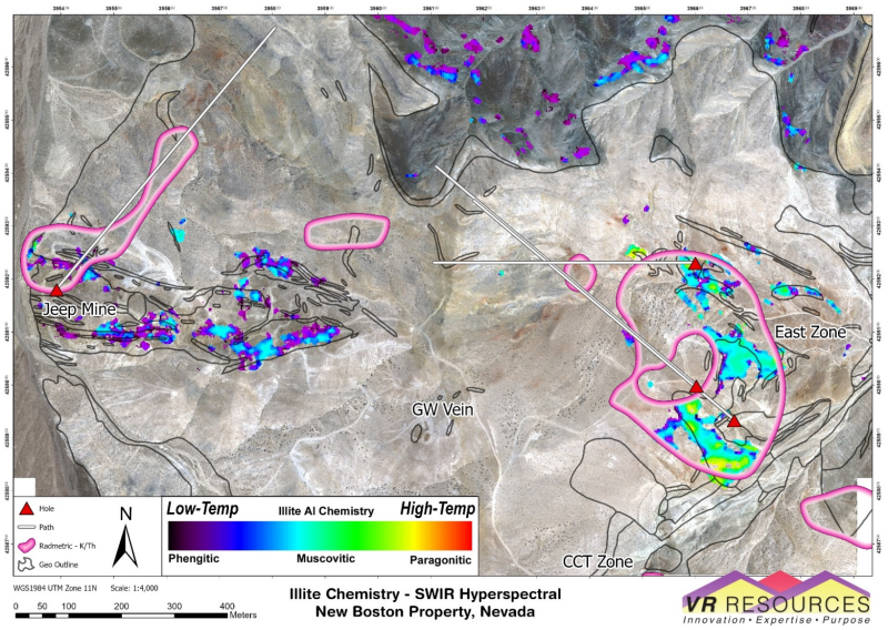
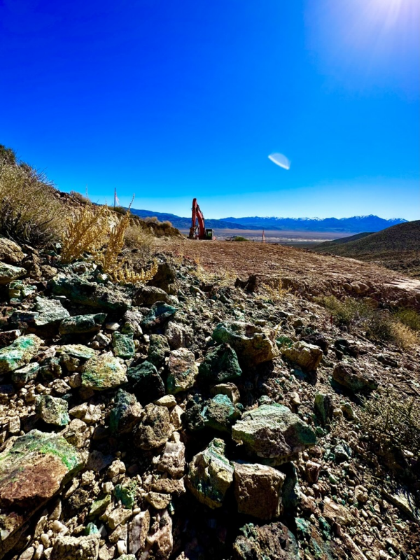
For example, Figure 1: There is a strong correlation between high temperature clay minerals identified by the new hyperspectral survey with the potassic alteration in East Zone outlined by our high resolution airborne radiometric survey completed last year. Figure 2: Our first planned drill hole will be collared in quartz vein rubble with copper oxide within that high temperature clay alteration, and will target the conductor plunging westward toward the central GW fault as identified in the new 3D array DCIP data also obtained last year.
There are no historic drill holes into the East Zone conductor; you don’t drill what you can’t see. But 45 years later, an array of new geophysical and geochemical tools are showing VR a zonation in the New Boston porphyry system across the central GW boundary zone and fault: in potassic alteration; in vein intensity and geometry; in IP and conductivity anomalies; in magnetic patterns; in alteration mineral assemblages, and; in copper geochemistry.
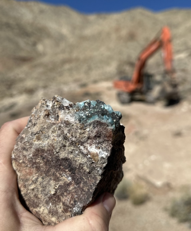
The excavator in the photo taken last week in Figure 3 shows you that we are ready to go. Please stay tuned as we mobilize this maiden drill program into what we believe is the high temperature center for copper vein stockwork mineralization in the eastern cell of the large footprint and polymetallic copper-moly-silver system at New Boston.”
Field Videos
A short video from the recent field visit, along with video from several previous site visits are available on the New Boston Project Page on the Company’s website at www.vrr.ca. Also, on the Home Page itself, is a 20 minute video review of the New Boston project and drill targets, illustrated in PowerPoint. Shareholders are encouraged to follow the Company’s YouTube and Instagram channels for further field updates as drilling progresses.
Technical Information
Summary technical and geological information for the Company’s various exploration properties including New Boston is available at the Company’s website at www.vrr.ca.
Technical information for this news release has been prepared in accordance with the Canadian regulatory requirements set out in National Instrument 43-101. Justin Daley, P.Geo., VP Exploration and a non-independent Qualified Person oversees and/or participates in all aspects of the Company’s mineral exploration projects, and the content of this news release has been reviewed on behalf of the Company by the CEO, Dr. Michael Gunning, P.Geo., a non-independent Qualified Person.
About the New Boston Property
Location
New Boston is within the Walker Lane mineral belt and structural province in west-central Nevada. More specifically, it is within the co-spatial belts of Jurassic – and Cretaceous-aged copper and moly porphyry deposits, including the Yerington camp and Hall deposit.
New Boston is located in the Garfield Range in Mineral County, approximately 150 km southeast of Reno. Vegetation is sparse in the range; outcrop or colluvium predominate on the property itself, with quaternary cover developed off its eastern border and eastern flank of the range.
The property location facilitates cost-effective exploration, year-round. Access is from the nearby town of Luning, located just 5 km to the east on State Highway 95 connecting Reno and Las Vegas. The property itself is criss-crossed by a myriad of active, historic trails and roads, which are reachable from the highway.
Property Description
The New Boston property is large: it consists of 77 claims in one contiguous block approximately 3 x 5km in size and covering 583 hectares in total (1,441 acres). It covers the entire extent of the known copper-moly-silver porphyry-skarn mineral system exposed on surface between Blue Ribbon and East Zone, and its inferred down-dip potential to the north.
The property is on federal land administered by the Bureau of Land Management (BLM). There are no state or federal land use designations, or privately-owned land which impede access to the property; nor is the property within the BLM’s broadly defined area of sage grouse protection.
The property is owned 100% by VR. There are no underlying annual lease payments; nor are there any joint venture or back-in interests. The vendor of the property retains a royalty.
Stock Option Allocation
The Company has approved an aggregate allocation of 1,725,000 incentive stock options at a price of $0.22 and exercisable for a period of five years to various directors, officers, employees and consultants to the Company, and in accordance with the terms of the Company’s Stock Option Plan
About VR Resources
VR is an established junior exploration company based in Vancouver (TSX.V: VRR; Frankfurt: 5VR; OTCQB: VRRCF). VR evaluates, explores and advances large-scale, blue-sky opportunities in copper, gold and critical metals in Nevada, USA, and Ontario, Canada. The Company has also made Canada’s newest diamond discovery in northern Ontario, and controls a new field of kimberlite targets around it. VR applies modern exploration technologies and leverages in-house experience and expertise in greenfields exploration to large-footprint mineral systems in underexplored areas/districts. The foundation of VR is the proven track record of its Board in early-stage exploration, discovery and M&A. The Company is well-financed for its mineral exploration and corporate obligations. VR owns its properties outright and evaluates new opportunities on an ongoing basis, whether by staking or acquisition.
ON BEHALF OF THE BOARD OF DIRECTORS:
“Michael H. Gunning”
____________________________
Dr. Michael H. Gunning, PhD, PGeo
President & CEO
For general information please use the following:
Website: www.vrr.ca
Email: [email protected]
Phone: 778-731-9292
Forward Looking Statements
This news release contains statements that constitute “forward-looking statements”. Such forward looking statements involve known and unknown risks, uncertainties and other factors that may cause the Company’s actual results, performance or achievements, or developments in the industry to differ materially from the anticipated results, performance or achievements expressed or implied by such forward-looking statements. Forward-looking statements are statements that are not historical facts and are generally, but not always, identified by the words “expects,” “plans,” “anticipates,” “believes,” “intends,” “estimates,” “projects,” “potential” and similar expressions, or that events or conditions “will,” “would,” “may,” “could” or “should” occur. Forward-looking statements in this document include statements concerning VR’s plans to drill its New Boston property, and all other statements that are not statements of historical fact.
Although the Company believes the forward-looking information contained in this news release is reasonable based on information available on the date hereof, by their nature forward-looking statements involve assumptions, known and unknown risks, uncertainties and other factors which may cause our actual results, performance or achievements, or other future events, to be materially different from any future results, performance or achievements expressed or implied by such forward-looking statements.
Examples of such assumptions, risks and uncertainties include, without limitation, assumptions, risks and uncertainties associated with general economic conditions; the Covid-19 pandemic; adverse industry events; future legislative and regulatory developments in the mining sector; the Company‘s ability to access sufficient capital from internal and external sources, and/or inability to access sufficient capital on favorable terms; mining industry and markets in Canada and generally; the ability of the Company to implement its business strategies; competition; and other assumptions, risks and uncertainties.
The forward-looking information contained in this news release represents the expectations of the Company as of the date of this news release and, accordingly, is subject to change after such date. Readers should not place undue importance on forward-looking information and should not rely upon this information as of any other date. While the company may elect to, it does not undertake to update this information at any particular time except as required in accordance with applicable laws.
This news release may also contain statements and/or information with respect to mineral properties and/or deposits which are adjacent to and/or potentially similar to the Company’s mineral properties, but which the Company has no interest in nor rights to explore. Readers are cautioned that mineral deposits on similar properties are not necessarily indicative of mineral deposits on the Company’s properties.
Trading in the securities of the Company should be considered highly speculative. All of the Company’s public disclosure filings may be accessed via www.sedarplus.ca and readers are urged to review them.
Neither the TSX Venture Exchange nor its Regulation Services Provider (as that term is defined in Policies of the TSX Venture Exchange) accepts responsibility for the adequacy or accuracy of this release
——
Figure 1. Hyperspectral data for clay alteration minerals plotted on Skywatch satellite image. The high temperature clays associated with potassic alteration at East Zone, outlined by the large, pink K/Th radiometric anomaly, contrast with the cooler phengitic clays at Jeep Mine. The clay alteration pixels corelate strongly with exposed mineralized porphyry dikes in both zones. The clay-chlorite and quartz alteration in the overlying dark grey argillite to the north of East Zone correlates with grid-based ICP-MS soil geochemical anomalies in the same area and are together suggestive of a source, buried porphyry stock at depth below the argillite. Solid white lines are traces for conceptual drill holes planned for 2024.
Figure 2. View east from the property last week, standing on the drill pad for NB24-001, the first hole in the pending drill program planned for this spring at New Boston, with State Highway 95 connecting Reno and Las Vegas in the valley bottom in the background. The blue-green copper oxide in quartz vein rubble in the foreground correlates with high temperature clay and garnet alteration minerals identified in the new, state-of-the-art airborne hyperspectral survey covering New Boston, and shown in Figure 1.
Figure 3. View west into the East Zone bowl last week, over the drill pad for the first hole in the pending drill program planned for this spring at New Boston. The piece of quartz vein material with copper sulfide and copper oxide was turned up by the excavator throughout the drill pad area, and supports the DCIP conductor which is modelled at surface at this location, and plunges back into the bowl in the background of the photo.
Copyright (c) 2024 TheNewswire – All rights reserved.
COMTEX_450220322/2895/2024-04-02T07:30:43


